Mapping Derry
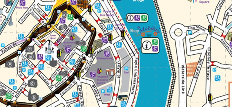
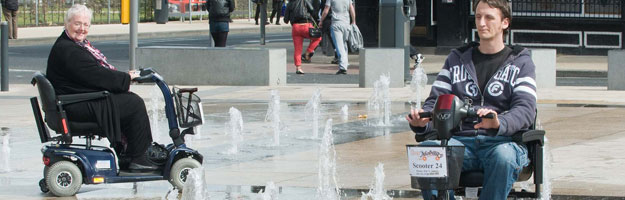
This week we interviewed Paula Martin from Bridge Accessible Transport who has worked on a project to create a map of Derry in Northern Ireland. The map aims to help disabled people navigate through the city. It shows where there are dropped kerbs, traffic lights with a rotating cone and accessible toilets. It also suggests a route around the city which avoids steep hills.
Where did the idea to create an accessible map for Derry come from?
The idea for the map came from our committee, our transport manager, Shopmobility Coordinator, and service users, looking to contribute to the “City of Culture” year in a way that would make it easier for people with disabilities to access activities and events that would be running all year long.
We set about drafting an Action Plan to capture ways that we could contribute to the accessibility of the city for local people our members and visitors with disabilities that would be coming to the city in the “Culture Year”. Lots of events were to take place such as the Christian Heritage trail, Herstory on the City Walls, Turner Prize, Concerts, Plays etc and the geography of the City can be troublesome for people using wheelchairs and scooters if they are not sure of the best route.
How did you go about creating the map? How long did it take to make?
We literally walked the entire city over and over again with some of our members who use wheelchairs and scooters. We took note of access issues and wrote to the local planning office to ask for assistance and work to be completed with dropped kerbs, signage etc. We scanned local maps, most of which had little or no references to easy access in any format.
We asked members to visit all the local attractions and record access issues and find out if the had accessible toilets or mobility equipment such as wheelchairs and scooters available.
We supplied mobility equipment to any venue that did not have any available, and trained staff in Health & Safety issues and how best to support people using the equipment. We met frequently with the Access officer from Disability Action who was seconded to City Of Culture and addressed issues of concern regarding access to activities and events.
We spoke to the local Tourist Board and they gave us great support and permission to use what we required from their current tourist map. We spoke with the local community and Public transport and Rail suppliers and provided mobility equipment for people at bus depots and train stations. It took the best part of four months in total, helped by an army of people, local councillors and public authorities.
Did you encounter any challenges?
Yes, many, many challenges, such as trying to be as inclusive as possible to as wide a range of people with disabilities, yet we didn’t have the skills/ funds/technology to provide the map in a format suitable for people who were blind.
We also put the poor graphic designer through the mill, with the constant changes, amendments, spelling errors and new additions to the map every week for one month before the final version was agreed. But it was worth it in the end.
The map is easy to read. Is this something that is important to you?
Very important, as we tried to present a map that contained lots of information but was still easy to follow. This task was the hardest part as wanted to ensure that key facilities such as transport, toilets, parking etc were covered but didn’t confuse people. We worked with the local RNIB (National Institute for Blind) group and promised to check out the technology available to see if we could transfer data to a format for their members. We will shortly produce a visual guide (photographs mostly) of the “Ramble around the Historic Walls”.
What advice would you give to someone who wanted to create their own map of their town?
Get a good team of committed people on board at the start, most importantly get your members/users/people with disabilities on board right at the start of your adventure. Review any accessible maps you can get your hands on and get agreement with how best you would like to present your map. Speak to people who have done it, they can provide great advice and assistance in the planning stages to help.
View a PDF version of the map.

 Follow Euan's Guide on Instagram
 Follow Euan's Guide on LinkedIn
 Follow Euan's Guide on Facebook

Comments
You have to be signed in to leave a comment.
Login / Signup